On this page
Taka Makassar is a crescent sandbar on a reef flat, not an island — no vegetation, no fresh water, and largely submerged at high spring tides. Cruises time the 45–90 minute stop for lower water and pair it with Manta Point at Karang Makassar, 20 to 30 minutes away.
What Taka Makassar actually is
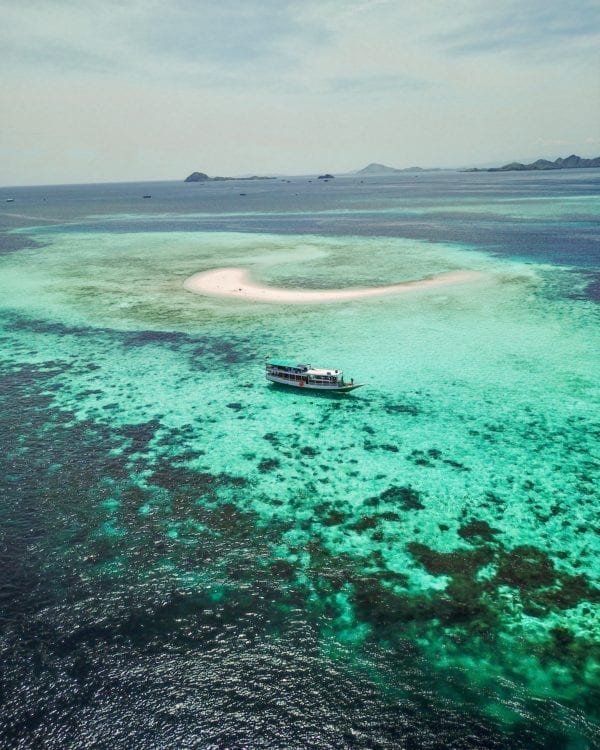
Taka Makassar is not an island. It is a sandbar — a crescent of coral sand sitting on a shallow reef flat between Komodo Island and Karang Makassar, with no vegetation, no fresh water and nothing permanent above the waterline. “Taka” is the local word for a reef that dries; the name is a description, not a place name.
This matters because it explains every complaint and every superlative attached to the stop. Guests who arrive at low water on a calm morning describe the best twenty minutes of the trip. Guests who arrive near high water on a windy afternoon describe standing shin-deep on a submerged sandbank wondering what the fuss was about. Both are accurate. The variable is the tide, not the place.
Tide is the whole story
| Water state | What the sandbar looks like | What you can do |
|---|---|---|
| Low water | Full crescent exposed, dry sand, clear shape visible from the deck | Walk the bar end to end, photograph, snorkel the reef edge |
| Mid tide | A reduced strip, damp sand, edges awash | Standing and photographing still work; the walk is shorter |
| High water, particularly spring tides | Largely submerged; a pale patch under shallow water | Snorkelling only — the reef edge is the reason to be there |
Tide state at any given hour changes daily. Cruise schedules are built around ranger queues, current and light, and the Taka Makassar window moves with them — which is why we publish sailing times as ranges rather than a fixed clock.
Why it is always paired with Manta Point
| Leg | Typical sailing time |
|---|---|
| Labuan Bajo → Kelor | about 1 hour (verified across operators) |
| Labuan Bajo → Kanawa | about 1–1.5 hours |
| Kelor → Manjarite | about 0.5–1 hour |
| Manjarite → Kalong | about 1 hour |
| Kalong → Padar (overnight run) | about 3–4 hours |
| Padar → Pink Beach | about 1–1.5 hours |
| Pink Beach → Komodo Island | about 0.5–1 hour |
| Komodo → Manta Point (Karang Makassar) | about 0.5–1 hour |
| Manta Point → Taka Makassar | about 20–30 minutes |
| Taka Makassar → Siaba Besar | about 1–1.5 hours |
| Siaba Besar → Kanawa | about 1–1.5 hours |
Karang Makassar — the site most boats call Manta Point — is 20 to 30 minutes from the sandbar. That proximity is why the two are always sold as one block. It is also why the order swaps: mantas at Karang Makassar are best on a running current, and the sandbar is best at lower water, so the crew sequences whichever window opens first on your dates.
If your guide announces at breakfast that the order has changed, that is competent seamanship rather than a downgrade. The full leg-by-leg schedule and the reasoning behind stop order is on the route map and sailing hours page, and the Pink Beach and Taka Makassar reality check — including what the colours really look like — is on the Pink Beach and Taka Makassar reality page.
The snorkelling, honestly
| Attribute | Taka Makassar reef edge |
|---|---|
| Depth | Shallow reef flat dropping away at the margins |
| Current | Light to moderate on the flat; stronger at the channel edges |
| Level | All levels with a vest; stay inside the guide’s marked area |
| What you see | Reef fish over hard coral, occasional passing rays from the neighbouring channel |
| Typical stop length | 45–90 minutes including tender transfers |
It is a pleasant reef, not a great one. The great reef is 25 minutes away at Karang Makassar, and the great structure is at Batu Bolong and the northern pinnacles. Taka Makassar is on the itinerary because standing on a sandbar in the middle of a national park is a genuinely strange and lovely experience — not because the coral is exceptional.
The photograph, and how to get it
Nearly every famous image of Taka Makassar is a drone shot taken low over the bar at low water with no other boats in frame. From the sand itself, at eye level, you are looking at a white strip and open sea — good, but not the postcard.
Flying your own drone inside Komodo National Park requires a permit of IDR 1,000,000 applied for at least seven days before departure; it cannot be arranged on the day. Professional drone, GoPro and mirrorless documentation is included in the Naturalia fare, which is how most guests come away with the aerial without dealing with the permit at all. The inclusion list is in what a Komodo cruise fare includes.
Protecting a sandbar that is slowly moving
Taka Makassar changes shape season to season under current and monsoon swell. It has no vegetation to bind it and no fresh water, so nothing recovers quickly. Walk on the wet sand rather than the dry crest, do not build or dig, take nothing, and keep fins off in the shallows where the reef flat starts. Anchor damage is a real and visible problem on shallow flats across the park.
Cabin rates, the vessel specification and how this stop sits in the wider itinerary are on the specifications and 2027 rates page.
Frequently asked questions
Is Taka Makassar a real island?
It is a sandbar, not an island — a crescent of white sand sitting on a reef flat with no vegetation, no fresh water and no permanent above-water land. Its shape changes with current and season, and at high spring tides much of it is under water.
Can Taka Makassar disappear at high tide?
Yes, substantially. The sandbar is only a metre or so above the water at its highest and it shrinks as the tide rises. Boats time the stop for lower water. If you arrive near high tide you may be wading on a submerged bar rather than standing on a beach.
How long do cruises stop at Taka Makassar?
Typically 45 minutes to an hour and a half, and it is usually paired with Manta Point at Karang Makassar which is only 20 to 30 minutes away. The order of the two swaps depending on current and wind, so the stop can fall in the morning or the afternoon.
Is there snorkelling at Taka Makassar?
Yes, on the reef edge around the bar rather than on the sand itself. Expect a shallow reef flat dropping away at the margins with light to moderate current. It is a gentler stop than the neighbouring manta drift at Karang Makassar.
Why does Taka Makassar look smaller than in photos?
Because most photographs are drone shots taken at low water when the bar is at maximum exposure and the crescent shape is clearest, often with no other boats in frame. At mid-tide with three boats anchored it is a smaller, busier place. That is not deception, it is tide.
Do you need a drone permit to photograph Taka Makassar?
To fly your own drone in the national park you need a permit costing IDR 1,000,000, applied for at least seven days ahead. Professional trip documentation including drone footage is included in the Naturalia fare, which is how most guests get the aerial shot without the permit.
Booking & enquiries
Naturalia Cruise is operated and marketed by Komodo Luxury (part of Juara Holding Group, working out of Labuan Bajo since 2015). Cabin availability, charter dates and written quotations go through the Komodo Luxury reservations desk: WhatsApp +62 811 3823 875 or sales@komodoluxury.com. Payment terms are published and unchanged: 50% deposit to hold the date, balance due 30 days before departure, full payment if you book inside 30 days, deposit non-refundable on cancellation.
Rates and tariffs on this page were last reviewed on 1 August 2026 and are quoted for the 2027 season. Vessel figures are the operator’s published specifications; national park tariffs are from PP No. 36 Tahun 2024. Always confirm the current rate in writing before transferring a deposit.